A BIT ABOUT THE DEVELOPMENT OF NAVIGATION
ON THE TENNESSEE RIVER and PART OF THE GREAT LOOP
The Tennessee and Cumberland rivers and their tributaries comprise most of the great drainage system harnessed for the production of electricity by the Tennessee Valley Authority and made -and kept- navigable by the U. S. Army Corps of Engineers.
A perusal of the Tennessee River navigation charts will show you that the river is commercially navigable from about TRM 650 at Knoxville to its confluence with the Ohio River at Paducah, KY at TRM 0. Note that the main stem of the Tennessee begins at Knoxville with the junction of the Holston and French Broad rivers.
As part of the Great Loop, your journey to cover the section of the Tennessee River from Kentucky Dam, TRM 25 to the Tennessee Tombigbee Canal at the mouth of Yellow Creek is one of much variety. You will find a lake, a river, many coves, sandbars, cliff, bluffs and many placid and peaceful waters. If you are a snowbird and traveling from the North to the South, then you will actually cruise through the Barkley Canal into Barkley Reservoir -just above the lowermost dam on the Cumberland River (CRM 30). These two major reservoirs are operated as a single hydraulic system so that there is no need for a lock between. Occasionally, you find a slight current in the mile-and-a-half canal.
–A TOUGH RIVER TO TAME–
When settlers first crossed the Appalachian mountains from the Virginia/Carolina area, they found that the French trappers and Spanish explorers had long preceded them in using the Cumberland and Tennessee rivers as their highways”. Of course, the Native Americans preceded them. But, the shoals, bars, “sucks” and other hazards naturally occurring owing to the geological history of the region didn’t bother those who traveled pretty light. The settlers came in flat boats with animals, household goods and merchandise. Nashville, TN, was established by a party, which came down the Tennessee River to the Ohio and thence up the Cumberland for about 200 river miles. In 1799, this group lost several boats, people and possessions in the infamous “suck’ below Chattanooga. This hazard was only one of many which dogged the development of safe navigation on the Tennessee for well over one hundred years.
During the administration of Thomas Jefferson (about 1810), officers of the Army Corps of Engineers began examining developing waterway routes in the Western Rivers -including the Cumberland and the Tennessee. From the beginning their efforts were hampered by the issue of who was to control the waterways -the federal government or the states through which they passed. This turned out to be a very divisive issue during the nineteenth century. When Albert Gallatin was Secretary of the Treasury, he recommended a national canal network designed to bind the young nation together. Later, after the War of 1812, John C. Calhoun ordered plans prepared for connecting waterways as a means for, the more complete defense of the United States.
The Corps of Engineers was ordered by the War Department to develop methods for improving navigation on the Western Rivers, the Mississippi and the Ohio and their major tributaries, as an ongoing task. The continuing vision was of an integrated system of waterways permitting river commerce both east-west and north-south through the central south. Be reminded that these visions were not fully realized until construction of the Tennessee-Tombigbee Waterway (TTW) began in 1975, -after nearly two centuries of discussion. In the interim, citizens of the states in the region -who were very familiar with all of the streams and the watershed divides- began discussing possible waterway improvements, often to be funded by private enterprise. A report to the Tennessee legislature in 1809 stressed the need for a waterway connection with the Gulph [sic] of Mexico. After all, the eastern portion of the nation was learning to enjoy the benefits of having canals connecting their major waterways. The Erie Canal in 1825, for example, became a busy waterway immediately.
Probably the most formidable obstacle to travel on the Tennessee River is at Muscle Shoals, actually a series of shoals stretching about 30 miles from about the mouth of the Elk River, TRM 286, to Florence, AL, TRM 256. These were eventually conquered by construction of Wilson Lock and Dam, TRM 259, and Wheeler Lock and Dam, TRM 275.
Long before the construction of Wilson Dam and Wheeler Dam more than one private enterprise tried to conquer these obstacles. A canal designed by an engineer with experience on the Erie Canal was planned to circumvent the shoals with a series of sixteen locks with an aggregate lift of 86 feet. Channels in the main river above and below were to be blasted through the remainder of the shallow stretch of stream. The flinty, very hard limestone comprising the bedrock -its great resistance to erosion causing the shoals-as well as disease and floods-proved to be the undoing of the financiers, and all who tried failed to complete the whole job. However, sixteen locks were eventually constructed along with twelve miles of canal. Because all construction work was essentially accomplished by man or animal power, the financial backers often sent their slaves and work animals to participate in the construction.
The national depression of 1837 ended hopes of completing this, monument to folly, as President Van Buren expressed it. Thereafter, a long period of wrangling over control of the river(s), plus bad economic times aided by politics at its very worst, delayed improvements to the navigability of the Tennessee River past the many other obstacles existing from Knoxville to its mouth. Col. John McClellan began work in earnest on the upper river to past Chattanooga in 1853. Some of the wing dams constructed to help keep a navigable channel open were visible and useful into the 1920’s; all were eventually covered by later impoundments.
The construction of further navigational improvements languished until after the War Between the States and the questions concerning federal versus state powers were settled by force of arms. During the war, the presence of shoals and other hazards greatly hindered movement of troops and supplies. The Battle of Shiloh, April 1864, was fought at Pittsburg Landing, TRM 198, because high water prevented Grant’s troops from landing where he had planned near the mouth of Yellow Creek, TRM 215 -now in Pickwick reservoir. Note that the confluence of Yellow Creek and the river marks the upstream terminus of the 450 mile-long TTW. Try to pick out Pittsburg Landing as you pass. For ninety years after the battle it maintained essentially its same appearance. In 1954, floods followed by rapid draw-down conditions caused the landing to slip into the river. The National Park Service has never had sufficient funds to restore the landing to its original condition.
Later in the nineteenth century, numerous ideas were studied regarding canals linking the Cumberland/Tennessee Rivers and the Ohio River systems to the east coast. For example, the James and Kanawha rivers were to be canalized, thus giving access from Ohio across Virginia. The Atlantic and Great Western canal was to connect the Tennessee River with the Altamaha across southeast Georgia. This route would have essentially linked today’s city of Atlanta with the Atlantic Ocean! The upper terminus of this great project was to be at Guntersville. AL!
The Muscle Shoals, the single greatest hindrance to end-to-end navigation of the Tennessee River, was again attacked by the letting of contracts for a canal and locks in 1875. Once again, the difficulties of excavation, the prevalence of malaria decimating the workers and the terrible weather caused abandonment of the project for lack of funds as one contractor after the other went broke. The whole scheme was revived in the mid-1880s with sixteen total miles of lateral canal (along and near the riverbank) and twelve miles of tough rock excavation being completed. One canal with two locks bypassed the Elk River shoals, TRM 284-285. Any remains of these features are now under water.
As if political and natural problems weren’t enough, the Muscle Shoals project had the honor of being robbed of its payroll by the James Gang on March 11, 1881. Major King, in charge of the project, was infuriated and had the robbers pursued. Eventually, they were captured at Nashville and most of the money was recovered. Jesse and Frank had maintained homes in the Nashville area; the “heat’ from the robbery forced them to flee to Missouri, where Jesse was assassinated a year later.
After fifteen years of arduous construction, the canal opened to traffic on November 10, 1890, and a steamboat passed, mostly unimpeded, from St. Louis to Chattanooga! I should point out that most canal/lock works were used only during low water stages. When the river stage was high enough, the locks were by-passed. The Muscle Shoals canal was finished under the direction of Capt. (later, General) George W. Goethals, who later gained fame as the engineer in charge of the construction of the Panama Canal. Capt. Goethals furthered his early reputation by directing construction (1891) of the canal and locks past Colbert Shoals. These locks, which he designed, were of about 26 feet of lift and were marvels of the time. I believe that the Colbert Shoals were located just downstream from Florence, AL, near TRM 250.
Lateral canals and small locks served their purpose until modern engineering made multi-purpose (navigation/flood control/power) projects feasible.
–THE NEXT GENERATION OF PROJECTS–
About 1900, the Hales Bar project (lock, dam and powerhouse) got under way. The dam and powerhouse were to be paid for by private interests while the federal government financed the lock. This endeavor, located about 33 miles downriver from Chattanooga at TRM 431, was a pioneer in the heavy design and construction business. Moreover, only the most rudimentary forms of subsurface exploration were known and used when construction began in 1905. Construction was slow on the 1,200 ft. dam and 39 ft. lift lock. Establishing a foundation in the highly solutioned Bangor limestone proved to be a real bear and the building effort stretched over eight years. After completion, leaks through the bedrock became more obvious and some experts estimated more water passed under the dam than through or over it! Huge sums of money were spent -to no avail. TVA acquired the dam in 1939, when it purchased all of the facilities of the Tennessee Electric Power Co. TVA spent a lot more money and finally gave up and replaced Hales Bar with Nickajack Lock and Dam six miles downstream at TRM 425.
During most of the first two decades of the twentieth century, wrangling over a variety of matters regarding financing, ownership, design, etc., prevented further solving of the Muscle Shoals ‘problem’. The private electric power companies of the region were reluctant to participate with the government in such projects -of a size and scope unknown in any part of the world. Bear in mind that it was long realized that a huge potential existed for the production of electric power within the river system as it descended more than five hundred feet from Knoxville to its junction with the Ohio.
World War I gave some impetus to development when President Wilson selected the Muscle Shoals area (Sheffield, AL) as the site of two plants to produce nitrates for munitions. The Corps of Engineers was ordered to begin construction of Wilson dam in 1918, to produce the electricity needed by these plants. After several delays in funding, work in earnest began -again, in 1921, on the (then) world’s largest dam and appurtenant works.
Over 4,000 workers descended on the site; ultimately fifty-six lost their lives in construction-related accidents. The size of the dam continues to amaze knowledgeable visitors; only the Aswan Dam on the Nile approached it in volumes of concrete in 1925.
President Roosevelt visited the site in 1933, and was so impressed that he was inspired to push for the creation of the Tennessee Valley Authority. Strangely, the then-gigantic powerhouse with eight generators and space for ten more was ready to go before any policy for delivery of electricity was formulated! Transformers on loan from the Alabama Power Co., delivered the current to their system.
The double-lift locks at Wilson were opened to traffic in June 1927; thereafter, the Wheeler project was completed and the great shoals were finally tamed.
–FINAL DEVELOPMENT–
With the creation of TVA a long-smoldering war between advocates of private versus public power development was laid to rest. But a turf battle between the Corps of Engineers and TVA emerged. Succinctly, the Corps envisioned a series of numerous low dams to foster navigation while the TVA favored “high” (higher and fewer) dams for maximum power development. In the mid-1950’s, these arguments were laid to rest, too, and construction of the current, multi-purpose projects along the main stems of the Cumberland and Tennessee rivers began in rapid fire order. To this day the power generation facilities are managed (mostly remotely) by TVA in Chattanooga and the Nashville District, Corps of Engineers oversees the navigation and flood control aspects.
–BITS AND PIECES–
Some years ago the Wilson double-lift locks located on the right bank (to your right as you pass downstream through the new lock) began to show evidence of movement in the river wall foundations as the lock was alternately filled and emptied. Essentially simultaneously with repairs, a new single-lift lock of 94 feet was built adjacent riverward. The old locks are now the auxiliary locks. As you pass through the lock chamber (600 ft x 110 ft), you will note its unusual -for this river system- vertical lift gate at the upper sill. The lower gates are mitered, as are all the others you will see.
Below Huntsville, TRM 353, you’ll see part of the Redstone Arsenal where NASA developed the Saturn V and many other space-related hardware items.
The Browns Ferry nuclear generating facility can be seen as you approach TRM 294. This plant produces an enormous amount of electricity and has been one of TVA’s more-successful nuclear operations.
At TRM 236.5, you pass under the bridge carrying the Natchez Trace Parkway from Tennessee to Alabama. This 400-mile-plus highway, built and maintained by the National Park Service, is now essentially complete from Nashville, TN, to Natchez, MS. In the early days, river commerce proceeded by flatboat from Nashville via the Cumberland, Ohio and Mississippi rivers to Natchez, New Orleans, etc., where goods-even the lumber comprising the boats-were sold. Entrepreneurs, soldiers, hunters, -robbers and murderers, too, -walked or rode horseback up the Trace -home again. The original Trace is visible in many places and a trip along any segment of the modern highway is well worth the effort.
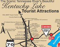
You pass Shiloh National Military Park shortly after entering beautiful Kentucky Lake. (Pickwick is the last locking on the Tennessee River trip.) For many miles the reservoir is essentially a river-bank-full run and the shores look pretty much like they did over a hundred years ago. Plan to visit the Shiloh battlefield in the future to understand and appreciate one of the bloodiest battles of the Civil War. Tour information, maps, highway directions and a courtesy car can be obtained from Birdsong Resort, Marina and Lakeside RV Campground at TRM 103.5. Call ahead and make a reservation at 800-225-7469.
As you travel downstream, you will now become aware of the fact that the river meanders so that you box the compass every few miles. The meandering is less obvious above Pickwick unless you note that the sailing line (channel) wanders all over the lakes. A broad tectonic uplift of the entire region many thousands of years ago incised the existing, low-gradient, meandering river into the bedrock below. Rapid (geologically) down-cutting produced the beautiful, sculpted -usually limestone- cliffs we see today. The most-resistant bedrock was hard to cut and produced the infamous shoals.
As you travel downstream below Pickwick and mostly north across all of western Tennessee and a small part of Kentucky, hard bedrock disappears as it descends to the west under a thick layer (thousands of feet) of sediments comprising the Mississippi Embayment. The latter stretches from the Gulf to the confluence of the Ohio/Mississippi at Cairo, IL, and east-west from the Tennessee River to Little Rock, AR. No hard rock is to be seen, anywhere, below Cairo along the Mississippi.
At Savannah, TRM 190, Civil War General Ulysses S. Grant had his headquarters after he had wrested control of the Tennessee and Cumberland rivers from the Confederates preparatory for his assault on Shiloh. A bed and breakfast currently is in his headquarters.
As you near the I-40 bridge, TRM 116, you’ll notice that the lake begins to widen. Kentucky Lake, which was formed in the mid 40″s begin it’s lake and behind you was the river….quite confusing to most but it is all the river and all the lake with about 1,000 miles of shoreline for the lake and 1300 miles of the river with a combined total of 2,300 miles of shoreline making it largest man-made lake in the America and one of the largest in the world. Over two-thirds of Kentucky Lake is in west Tennessee and only one third is in the state of Kentucky….. again, most confusing for many northern tourists making this leg of the Great Loop.
At Birdsong Creek, TRM 103.5 is the home of the ONLY Freshwater Pearl Farm, Tour and Pearl Jewelry Showroom in America, located on the 58-acre recreational complex of Birdsong Resort, Marina and Lakeside RV Family Campground. The owners, Bob Keast and Family have been operating their family styled facility since 1961. Only two other families join the Keast’s as original owners from when the Kentucky Lake was formed in the mid 40’s to be operating their resort and marina today in a new century. Longevity and loyal dedication is the key to their southern hospitality resort. Their business is your pleasure.
At TRM 96, look at Pilot Knob on the western shore. The “knob” is one of the highest points in western Tennessee and was the lookout for General Nathan Bedford Forrest to lookout over the river and establish his plan to invade the Union Gunboats and supply depot during the Civil War in the 1860″s.
A guided lake and bus tour from Birdsong Resort and Marina can be enjoyed by advance reservations to the knob and other tourist attractions in the peaceful southern town of Camden, Benton County Tennessee. Visit their website www.birdsongresort.com and click on Civil War Tours. Birdsong is also host to the Tennessee River Shipwreck, Derrick Boat # 9 from the Corps of Engineers dating to around the 1900. This old vessel was brought up as part of Raise the Gunboats effort to discover, raise, identify, conserve and display boats from the Civil War. Be sure to visit their site, www.gunboats.com for more current activity.
At Paris Landing, TRM 66 you’ll note that the right bank landscape is barren of development-all the way on your cruise to Grand Rivers, KY. The entire area between the Cumberland and Tennessee rivers, the Land Between theLakes, was owned by TVA but in 1999 they transferred the 1.2 million-visitor park to the US Department of Agriculture, Division of Forestry. No permanent residents, no commercial development; it is operated like a national park. Visit this wonderful historic area at your convenience.
At the end of your trip you will have traveled along the river through four states: Alabama, Mississippi, Tennessee and Kentucky -all Indian-derived names.
–MORE ABOUT THE HISTORY OF THE TENNESSEE RIVER–
Some time ago, I came into possession of a 70-plus page pamphlet recounting the history of the ST. LOUIS AND TENNESSEE RIVER PACKET COMPANY, one of many founded in the later years of the nineteenth century. The Company was owned by a young man from Nashville who went to the river” at age 18 and by age 22 was part owner of the steamboat WESTWIND -which got caught in the ice at Memphis, wrecked and sank during the winter of 1872. John E. Massengale started over, established himself in St. Louis, acquired ownership of several small steamboats, and put them to work in river trades running out of St. Louis. By 1896, the St. Louis and Tennessee River Packet Co. was in business on the Tennessee River by establishing regular runs from St. Louis, MO, to Cairo, IL, (200 mi). up the Ohio to Paducah, KY (150 mi.) and thence up the Tennessee to Florence, AL ( 300 mi.) Be reminded, Florence, just below the Muscle Shoals, was the head of dependable navigation. The round trip was over 1,000 miles on three rivers -passing through some of the most beautiful country on the western rivers. I also point out. that these stern-wheel packets drew no more water than our own wooden boats -often as little as twenty inches and hardly ever more than three feet. Often, in the fall low water ended travel all the way to Florence, so goods to be shipped piled-up at landings and prospective passengers had to find other, less comfortable means of travel. Of course, winter ice at St. Louis and below shut down everything- just as it does today. Tennessee River trade for the Company thrived and they bought more boats and increased the frequency of travel. About 1888, they made a bid for tourist travel -which really caught-on. The 8-day round trip (speedy!), St. Louis to Florence and return-including meals and berth- went for the staggering sum of $10. Incidentally, there were 69 listed landings between St. Louis and Cairo; 8 between Cairo and Paducah; and 271 (!) between Paducah and Florence, making 349 served by the packet company.
One of the major stops was Savannah, TN (TRM 190), to visit the Cherry Mansion where Grant had his headquarters during the Battle of Shiloh. Be sure to visit the mansion some time. After Shiloh Military Park was established, it became a drawing card for veterans -both Yankee and Confederate- and their families. Parenthetically, the visiting veterans are the reason the Shiloh battlefield is so well documented, as each recalled and could point out exactly where he was at any one point in the terrible battle.
“Decoration Day”, always May 30, became a time when all of the packets were filled with tourists. In fact, demand for passage was so great that boats often had to pass large crowds waiting, for example, at Saltillo (TRM 172), or Coffee Landing near Savannah (TRM 185.9). As an aside, Shiloh’s crowds also came by buggy, wagon, hack, horseback and afoot.
As the years passed, the steamboat business grew and prospered, the river traffic connected with the burgeoning railroad lines -carrying both passengers and freight. For example, the packets connected with the NC&StL at Perryville, TN (TRM 135.5) and Johnsonville, TN (TRM 78.3) for Nashville and Memphis and at Danville (TRM 78.0) for Memphis, Louisville and Cincinnati. You can still see the old railroad embankment and the dock at Danville between TRM 78 and TRM 79.
Another revenue generator for the Massengale boats was their mail contracts. Today, the sternwheeler DELTA QUEEN is a mail boat and has its own postmark and thus can take precedence in locking through ahead of commercial tows.
Of course, in addition to passengers and mail, the boats carried every conceivable form of merchandise -from setting hens and eggs to coal, iron, buggies, peanuts, cotton, machinery, etc.
Travel on these boats could be a real adventure. The little pamphlet recounts many, many disasters. Many boats were lost -sank after hitting snags, boilers blew up, and they caught fire and so on. Insurance was expensive! Sometimes the boats and their cargoes were salvaged; the boats repaired and put back into service or sold elsewhere (“pre-owned” boats?)
Hazards -snags, rock ledges, shifting sandbars- took their toll. Only recently has the series of shallow rock ledges just below Pickwick been removed. A.C.B.S.’s Mike Wilhelm and his towboat participated in this effort. To this day barges get stuck on bars, get loose and run aground. The river never changes; it’ll get you if you don’t watch out!
As with autos and planes, boats got bigger and fancier-they also cost more to build. After 1900, new boats such as the SHILOH (150 ft long and 28 ft wide) had full-length cabins and electric lights and cost about $50,000 to construct.
Nonetheless, river-borne travel was the way to go in style. (I think it still is!) Roads were dirt and often impassable. One lady of the time wrote that she and her father, then living in Florence, would hear the boat whistle and start the drive in their car. If the road got too muddy, they left the car, pulled-off their shoes, waded barefoot and, “were welcomed on the boat in that manner.
The high point of operations occurred about 1916. By April 1917, we were at war; the round trip Shiloh Battlefield fare was still only $15 and all the boats were busy with the war effort. Years passed, overland road and rail travel improved immensely, but river travel continued to do well in spite of losses caused by burning, sinking, etc.
Captain Massengale passed-away in 1924; his son became president of the line, but time had run out and the Great Depression took its toll. Moreover, the great floods of 1936 and 1937 hastened the Company’s (and others) demise. In December 1942, the Company charter was dissolved after 55 productive years.
This story contributed by my friend and classic/antique boat owner Ray T. Throckmorton, Jr. of Brentwood, Tennessee.